
The Jr. Imagery Analyst will annotate and validate remote sensing imagery, ensuring quality and consistency while using geospatial tools and following guidelines.
Please review the job details below.
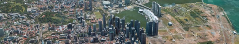
Maxar is seeking a motivated Imagery Analyst (Data Annotation Specialist I) to join our team. You'll work on the front lines of training and validating computer vision models by annotating and reviewing EO, SAR, and other commercial imagery. This is a great opportunity to start or grow your career in geospatial analytics and remote sensing.
What You'll Do
Minimum Qualifications
Preferred Qualifications
#LI-RD
In support of pay transparency at Maxar, we disclose salary ranges on all U.S. job postings. The successful candidate's starting pay will fall within the salary range provided below and is determined based on job-related factors, including, but not limited to, the experience, qualifications, knowledge, skills, geographic work location, and market conditions. Candidates with the minimum necessary experience, qualifications, knowledge, and skillsets for the position should not expect to receive the upper end of the pay range.
• The base pay for this position within Colorado is: $56,000.00 - $94,000.00 annually.
• The base pay for this position within New Jersey is: $56,000.00 - $94,000.00 annually.
• The base pay for this position within California is: $65,000.00 - $107,000.00 annually.
For all other states, we use geographic cost of labor as an input to develop market-driven ranges for our roles, and as such, each location where we hire may have a different range.
We offer a comprehensive package of benefits including paid time off, health and welfare insurance, and 401(k) to eligible employees. You can find more information on our benefits at: https://www.maxar.com/careers/benefits
The application window is three days from the date the job is posted and will remain posted until a qualified candidate has been identified for hire. If the job is reposted regardless of reason, it will remain posted three days from the date the job is reposted and will remain reposted until a qualified candidate has been identified for hire.
The date of posting can be found on Maxar's Career page at the top of each job posting.
To apply, submit your application via Maxar's Career page.
Maxar Technologies values diversity in the workplace and is an equal opportunity/affirmative action employer. All qualified applicants will receive consideration for employment without regard to sex, gender identity, sexual orientation, race, color, religion, national origin, disability, protected veteran status, age, or any other characteristic protected by law.
Maxar is seeking a motivated Imagery Analyst (Data Annotation Specialist I) to join our team. You'll work on the front lines of training and validating computer vision models by annotating and reviewing EO, SAR, and other commercial imagery. This is a great opportunity to start or grow your career in geospatial analytics and remote sensing.
What You'll Do
- Perform annotation tasks including bounding boxes, segmentation masks, and center points across EO and SAR imagery
- Validate existing annotations for quality and consistency
- Classify objects, detect errors, and flag anomalies in annotated datasets
- Apply feedback and follow established annotation guidelines
- Use industry-standard tools such as QGIS, ArcGIS, or other geospatial software (training provided)
- Collaborate with teammates and annotation leads to ensure high-quality output
Minimum Qualifications
- U.S. citizenship
- Interest or background in GIS, remote sensing, computer vision, or imagery analysis
- Strong attention to detail and visual acuity
- Ability to work independently and follow annotation protocols
- Proficiency with Windows and web-based tools
Preferred Qualifications
- Experience using geospatial tools (e.g., ArcGIS, QGIS)
- Exposure to EO or SAR imagery in coursework, research, or professional settings
- Familiarity with geospatial data formats or labeling tools
#LI-RD
In support of pay transparency at Maxar, we disclose salary ranges on all U.S. job postings. The successful candidate's starting pay will fall within the salary range provided below and is determined based on job-related factors, including, but not limited to, the experience, qualifications, knowledge, skills, geographic work location, and market conditions. Candidates with the minimum necessary experience, qualifications, knowledge, and skillsets for the position should not expect to receive the upper end of the pay range.
• The base pay for this position within Colorado is: $56,000.00 - $94,000.00 annually.
• The base pay for this position within New Jersey is: $56,000.00 - $94,000.00 annually.
• The base pay for this position within California is: $65,000.00 - $107,000.00 annually.
For all other states, we use geographic cost of labor as an input to develop market-driven ranges for our roles, and as such, each location where we hire may have a different range.
We offer a comprehensive package of benefits including paid time off, health and welfare insurance, and 401(k) to eligible employees. You can find more information on our benefits at: https://www.maxar.com/careers/benefits
The application window is three days from the date the job is posted and will remain posted until a qualified candidate has been identified for hire. If the job is reposted regardless of reason, it will remain posted three days from the date the job is reposted and will remain reposted until a qualified candidate has been identified for hire.
The date of posting can be found on Maxar's Career page at the top of each job posting.
To apply, submit your application via Maxar's Career page.
Maxar Technologies values diversity in the workplace and is an equal opportunity/affirmative action employer. All qualified applicants will receive consideration for employment without regard to sex, gender identity, sexual orientation, race, color, religion, national origin, disability, protected veteran status, age, or any other characteristic protected by law.
Top Skills
Arcgis
Geospatial Software
Qgis
Similar Jobs at Maxar Technologies
Aerospace • Artificial Intelligence • Computer Vision • Software • Analytics • Defense • Big Data Analytics
As an Imagery Analyst, you'll validate geospatial data annotations, conduct quality assurance, and support AI/ML workflows with EO and SAR imagery.
Top Skills:
ArcgisJupyterPythonQgis
Aerospace • Artificial Intelligence • Computer Vision • Software • Analytics • Defense • Big Data Analytics
Lead the quality validation of geospatial imagery annotation, mentor junior annotators, and enhance annotation standards for AI/ML development.
Top Skills:
ArcgisJupyterPythonQgis
Aerospace • Artificial Intelligence • Computer Vision • Software • Analytics • Defense • Big Data Analytics
This role involves designing, implementing, and optimizing SAP S/4HANA solutions while collaborating with business and technical teams to ensure effective communication and solution integrity.
Top Skills:
AbapFioriSalesforceSap BtpSap S/4Hana
What you need to know about the Ottawa Tech Scene
The capital city of Canada and the nation's fourth-largest urban area, Ottawa has proven a rapidly growing global tech hub. With over 1,800 tech companies, many of which are leaders in their sectors, the city's tech talent now makes up more than 13 percent of its total workforce. This growth is driven not only by the big players like UL Solutions and Dropbox, but also by a thriving startup ecosystem, as new businesses emerge to follow in the footsteps of those that came before them.